Suitable Areas for Forest Management in Glacier National Park
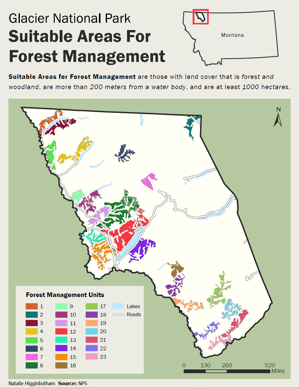
Suitable areas for forest management are the following criteria: land cover should be forest and woodland, management units should be more than 200 meters from a water body, and forest management units should be 1000 hectares, and have a unique identifier.
Executive Summary
The goal of this research is to provide the National Parks Service information on the areas best suited for forest management given the following criteria : land cover should be forest and woodland, management units should be more than 200 meters from a water body, and forest management units should be 1000 hectares, and have a unique identifier. Data was collected from the National parks service to perform this analysis. A sensitivity analysis was also performed to evaluate how the parameter of distance from a water body impacts the resulting number of forest management units. The units tested were 100 meters and 500 meters away from a water body.
The findings for the initial water body buffer of 200 meters provides the NPS with 23 different locations suitable for management. The results of the sensitivity analysis show that changing the buffer distance from water bodies greatly impacts the resulting output of forest management units. Attention needs to be paid when assigning a value for the distance to a water body. Changes in regulations on distance to water bodies greatly impacts the number of manageable forest units. When changing the distance value, total area increases and total area increases and decreases and so do the management units. When decreased to 100 meters, forest management units increase by 10. Increasing the buffer distance to 500 meters caused units to decrease by 10.
Analysis Summary
The purpose of this project is to identify which areas are suitable for forest management. The NPS would like to have a map identifying which locations are suitable. They provided multiple parameters that need to be met. They are that land cover should be forest and woodland, management units should be more than 200 meters from a water body, and forest management units should be 1000 hectares, and have a unique identifier. The first objective that needs to be solved is determining what areas are forest or woodlands. The data we need to solve this portion is Glacier National Park Vegetation Cover. To do this you would reclassify land cover information to have 1= forests/woodlands. The next step would then be to figure out which areas are more than 200 feet away from water bodies. In this layer we would use a shapefile of streams and one of lakes. To achieve this one would use Euclidean distance to measure the distance between the lakes and streams layers separately. These layers would then be reclassified with areas more than 200ft being =1 and the rest would be equal to no data and then both would be combined into a single raster using Boolean or. The output would then be combined with Forest and woodland vegetation cover using Boolean and, to show which areas are located more than 200ft from a water body but are also forest or woodlands. Once this output is completed, the Region Group tool could be used to assign areas that are clustered unique identifying values. Then zonal geometry could be used to see the area of the clusters. At this point, the raster calculator would be used to acquire the area in hectares (divide area by 10000). After this, the resulting layer would be reclassified to with 1= areas larger than 1000 hectares. The output would give us areas that are possible locations for forest management. To get them into unique forest management units, the Region Group tool would again be used to identify clusters and assign the clusters to unique values. Buffers of 100 m and 500 m were then used to conduct a sensitivity analysis.


